A method for evaluating the interaction between commuting distance, travel mode choice and job-choice
dr.Willeke J. Kribbe.
Faculty of Civil engineering and Geodesie
Infrastructure planning group
Technical University of Delft
Postbox 5048
2600 GA Delft
Summary
The contribution describes a fictitious case study to the effects that are possible and likely at the introduction of a new type of network on the use of the existing networks at a global level for the specific purpose of commuting. It is based on a rather simplistic but effective representation of consumer behavior with respect to commuting.
The method used was developed for the evaluation of structures consisting of living area, working area and the network connections in between them. It can be applied in urban area with multiple (de)-central employment centers. The assumption is that the research area can be subdivided in non-overlapping sub area. For these sub area data concerning potential labor force and jobs have to be known. In the Dutch situation this is the case for subdivision in municipalities.
The basic ideas in the method are borrowed from transportation theory; the basic algorithm from optimization and the data come (through Internet) from publicly available sources. The availability of these data sources makes it possible to "plan Holland" from anywhere in the world. The question if this is a desirable development will not be discussed in this paper.
The method was intended to answer questions as:
· Can smart planning of either employment centers or new living area reduce the average commuting distance?
· Can the creation of new networks or modification of existing ones influence the process of commuting?
Preliminary results (in [4] and [5] ) however indicated that for the Dutch situation the effects on the average commuting distance for the first type of above mentioned planning situations are marginal. However the method does seem to have potential for the analysis of effect of changes in the network(s). The contribution shows this potential using a fictitious case. The main evaluation criterion used is the number of displacements. The average commuting time (in minutes) is presented as well.
Introduction
The existing empirical literature on case studies concerning commuting is dominated by American or Japanese data. Little is published concerning European data. Moreover, many of the current evaluation methods described in literature for analyzing the interference of people and jobs both empirically and theoretically are of a contemplating nature and not suitable for use in planning processes.
The method used here can (provided validity in the relevant sub area can be proven) be used in the process of planning at a relatively high conceptual level. The number of types of parameters (1) the amount of types of data (2) by sub area in the model are limited. Therefore the method can never replace completely the more advanced traffic modeling approaches. The parameter in the method that represents the relative preference for distances can be adapted by sub area. This makes it possible to diversify between sub area that are traditionally densely populated (such as rural areas with little regional employment where people either have their jobs at home or have to travel relatively large distances) and area with high densities, such as city centers. In the current study such a diversification has not been made yet.
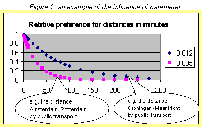
Figure 1 shows the effect of different parameter values on the consumer preference function. In a "full" area maybe only 5 out of 100 people would think the distance in travelling time minutes of 80 (corresponding e.g. to the distance between Amsterdam and Rotterdam by public transport) would be still acceptable. For such a sub area a parameter value of –0,035 would be representative. In a "dense" area this threshold value could lie along 240 minutes (e.g. corresponding to the distance Groningen – Maastricht by public transport). For such a sub area a parameter value of –0,012 could be used.
|
In this contribution I will describe the steps that have to be taken to "solve" the problem in the fictitious case study. I hope it will lead to similar approaches followed by scientists and practitioners elsewhere in the world and I would like to get in touch with those who do.
The method has been implemented in visual basic EXCEL.
The problem
The process of commuting is one of the major processes responsible for traffic jams (files) on roads and in delays in trains. It accounts for approximately 40% of the displacements (registered in the OVG, a Dutch database that contains data about trips that actually have been made by travelers). Files are generally considered to be a problem for which in politics a variety of possible "solutions" is considered circulates from "toll roads" to "paying for a price depending on where and when you drive" and "construction of new modalities". Sound evaluation methods for these "solutions" are not abundant and influencing consumer behavior has appeared to be a difficult if not impossible task over the years.
The question if commuting has to be considered as "wasteful" has been a topic in traffic economy in other areas than in Holland in the past twenty years (an overview is for instance given in references [2] ,[6],[8],[9],[11] and [14]). A definite answer cannot be expected. In the computations here the approach is adopted that whatever the reasons may be there is a division between travel alternatives that may be described as a logit function. The behavior of the consumer (traveler) groups that depends on time, distance or cost can than be described as satisfying behavior instead of optimizing behavior.
As most promising of the significant parameters influencing the commuting process, was chosen "the number of jobs" and as second best "the potential number of employees" (a derivative of the total number of inhabitants). These variables are assumed crucial.
The case
The case study considered consists of eleven locations (municipalities). Data (for these (and other) locations for the "banen van werknemers" and the "totale bevolking" for the years 1988-1999) are available from www.CBS.nl (the site of the Dutch national statistical office). You may download them using STATLINE from the "Statistisch bestand gemeenten". In this case study some data of surrounding municipalities that strongly rely on the larger ones are added.
Besides the economic parameters the network (in the case study this means data for travelling time) data are essential. In earlier studies ([4] and [5] ) there appeared to be no essential difference in application of the method if instead of the criterion "traveling time" criteria as "traveling cost" or "traveling distance" were used.
Network data are used for three types of networks,
· the existing public transport network
· the existing road network
· a third completely new network (estimated)
The data for the first two types of networks can be assembled using Internet sources as route planners. The estimates for the third one came from a private source. The procedure of data gathering through Internet is still somewhat awkward, as the data have to be assembled element by element from different sites. Availability of network data (and other essential data from the spatial data infrastructure) in a STATLINE like database, as was used for the consumer data, could make this process much more efficient.
An advantage of the data in the route planners is that these data are available at a postal code level. Data concerning the number of jobs and the number of inhabitants are only available at the municipality level. (Where "available" means "open to public"). A municipality sometimes includes over 100 4-digit postal codes, and the jobs and inhabitants are not evenly spread over these codes. For a reliable evaluation of consumer behavior, information about how these data are distributed over the postal codes would be necessary. If for this type of research these types of data can be made available is at the time of writing still an open question.
Data about "the actual number of trips made in this area" for the years 1995-1998 were available too from the OVG-database.
The approach
Step 1) Based on the above mentioned yearly data from (1988-1998) a prognosis is made for the year 2010 using linear and logarithmic regression. Linear regression seems to give the better fit for the job data. Logarithmic regression produces a better fit for the data concerning inhabitants. The average growth in the case study area of the population was approximately 0,5% over these years (with individual exceptions of smaller centers up to 3%. The average growth of the number of jobs 1,5%, with individual exceptions of the smaller ones up to 5%.
Step 2) The combined network data are use to create a "relative preference matrix" (based on the relative preference function) that indicates the attractiveness of working in a location from another location. The matrix includes data for all modalities, which means that it combines the traditional two step procedures of trip generation and modal split. This matrix may even include the most promising alternatives using a change of modality. To make the example not too complicated in this contribution that option is omitted. For individual entries in this case study the differences were up to 6,5% as compared to traditional two-step results. For the total number of trips generated the differences between this approach and the traditional one can be neglected.
Step 3) The relative preference matrix is used as the initial matrix in the doubly constrained trip generation process of which the principles are described in [7] . This makes the trips feasible for their purpose. This process is essentially a fixed-point algorithm. It is known that the results of these algorithms can strongly be influenced by initial conditions. The choice of the initial matrix (the relative preference matrix) therefore is very important. In traffic models the initial matrix is usually based on the existing situation and filled with the current displacements, sometimes augmented with survey data in case new locations have to be considered. For the purpose of the evaluation of a new modality however there is no existing situation available. The process of filling the initial matrix with a relative preference matrix creates a “fair” comparison for the new modality.
Step 4) This step consists of a sensitivity analysis for the system as a whole. As the network data appeared to have a major impact on the results, several options for the networks were calculated. Different logit parameters (2 parameter values), travel or driving times and the introduction of the third modality were considered. This resulted in 8 estimates corresponding to these options for each year, with the same number of total displacements but differing numbers of external displacements. The calculations were made with real data for the year 2000 and (according to step 1) estimated data for the year 2010. The total displacements in the model depend on the numbers of jobs and employees only. The external displacements (the displacements where is traveled outside the area) are determined endogenously by the model. They depend on the preference parameters, the times and the modalities available. Especially the influence of using travel or driving times and the choice of parameters on the percentage of external displacements of the total displacements is considerable and shows from figure 2. Other interesting, parameter depending, figures are the percentages of the individual modalities in the external displacements. They can be seen in figure 3.
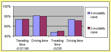 Figure 2: Four calculation options concerning "parameter value" and "type of time" for two alternatives showing the influence on the percentage of the external displacements in the total displacements |
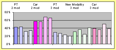 Figure 3: Influence of the new modality on the percentages of the modalities in the external displacements for the four options concerning parameter and time (in the same order as in figure 2) |
Step 5) The
next step is an analysis of the results of the individual displacements between
locations. (A sensitivity analysis for the locations). They can be done using
graphs as shown in Appendix A. The
graphs can be used to show the displacements by modality or by total. The four
graphs presented in Appendix A show
for each calculation option the relative distribution of the new modality displacements.
(N.B. The sum of these 121 columns adds to 100). From this type of graphs you
can see that the different calculation options for a specific location may lead
to rather dramatic differences. If you follow the column from location 6 to
location 11 (the yellow one) you will find differences from 2 to 3,5 % which
is rather significant considering the maximum percentage in this graph is approximately
4 %. You can also see that the “balancing process” has significant influence,
as the graphs are not symmetric. It is very clear that in such situation more
detailed models are needed to predict the local effects.
Conclusions from the case-study
In a similar way as in step 4 graphs from the model results can be made for the level of use of the modalities in the year 2000 and with predictions for 2010. For all the computational options these levels are shown in Appendix B for all modalities.
The following conclusions can be drawn from the experiments.
· The expected level of car use in 2010 will be lower (for all options valid!) than the current level of 2000 if the third modality is introduced. (NB: compare the first set of columns with the last set of columns). On the average the car displacements will be reduced with 24% if compared to the situation where the third modality is not realized. (NB: compare the third set of columns with the fourth set of columns). The total number of displacements increases with 15% over this period.
· For the expected level of the conventional public transport in 2010 the results are similar: on the average they will be reduced in comparison to the “do nothing alternative” with 25%.
· The expected level of use of the new modality will be in between the level of car use and the level of the conventional public transport. In numbers this means that the level is comparable to the level of public transport in the year 2000.
· Introducing the third modality will not influence the total number of external displacements.
Further experimental analysis with the case study
With the case study above some additional sensitivity analysis has been performed. This was driven by the following motivation: looking at the fact that the five smallest of the eleven locations together account for less than 5% of the total displacements. The analysis was repeated for the case that these 5 stops wold not be implemented so only 6 stops would be implemented for the new modality. This could have as an additional benefit that the net driving time would decrease for a number of tracks as the number of in-between stops between locations was reduced. Surprisingly enough the effects were rather large. The total decrease in the use of the new modality was by this measure, averaged over the four computational options, approximately 10.8% of the total displacements if the driving time was not changed! If the reduced driving times were taken into account the decrease was a smaller but still up 10.0%. This is still almost one third of the original estimates!
Conclusions
The match of the 2-modality results with the actual results seemed to be rather good on a system level. On local level, considering the problems with the aggregation level of the data, they were reasonable. The differences were in situations where the actual number of displacement was obviously caused by other reasons than commuting. However the sensitivity for parameter values is very high at a local level.
The method gives hope for the predictions of the results of the 3-modality alternative, if this new modality is beyond its introduction period. This is when it is comparative (and preferably better) to the conventional public transport in criteria as image, price, parking possibilities and transfer connections.
It can be useful (and cheap) for global analysis. Its ease of application is an advantage as it is due to the sensitivity for the parameters and other assumptions (such as the number of stops) not advisable to restrict the analysis to “one run” with “one set of predefined” assumptions. In a real-life situation implementation in a DSS-like environment is an essential key to success!
In its current form however it is not suitable for local analysis. The method deserves to be applied to data on a lower aggregation level (such as the postal code level).
References
[1] Goeverden, drs C.D. van & Sanders, prof.ir.F.M., “Accessibility of industrial and business areas”, Nectar Conference, Delft, October 1999
[3] Kribbe, dr.W.J. “Evaluating structures of connections”, in: Advances in Building Informatics , ed: Reza Behesti Europia 2001, Delft, april ISBN 2-909285-20-0
[4] Kribbe, dr.W.J., “Een evaluatiemethode voor de allocatie van nieuwe woon- en/of werkgelegenheid”, Arnhem, PLDD september 2000 (in Dutch)
[5] Kribbe, dr.W.J., “Hoe veranderen de posities van de locaties in een systeem onder invloed van veranderingen in netwerkparameters”, Arnhem, PLDD september 2000 (in Dutch)
[7] Ortuzar,J.D.de,& L.G.Willumsen, “Modelling Transport”, 2nd Edition, Wiley 1994
[10] White, Michelle ``A Simulation Model of a Decentralized Metropolitan Area with Two-Worker, `Traditional' and Female-Headed Households'' (with D. Hotchkiss), Journal of Urban Economics, vol. 34, 1993, pp. 159-185.
[12] White, Michelle ``Housing and the Journey to Work in U.S. Cities,'' published in Housing Markets in the United States and Japan, edited by Yukio Noguchi and James Poterba. N.B.E.R./University of Chicago Press, 1994.
[13] White, Michelle ``Location Choice and Commuting Behavior in Cities with Decentralized Employment," Journal of Urban Economics, July 1988.