New Urban Growth Centres in a Deltametropolis Transportation system
By: F.M. Sanders and W. Ruiter
Summary
Accessibility is an important criterion for the allocation of housing, commercial activities, and public facilities. In urban areas most of the business districts are characterised by a mono-modal accessibility inherent to the existing transportation system.
In urban planning the scope should be more focussed on the integration of landuse and transportation to enable the development of new growth centres with a first-rate multimodal accessibility. Doing so, the spatial transformation of urban areas will be stimulated as well.
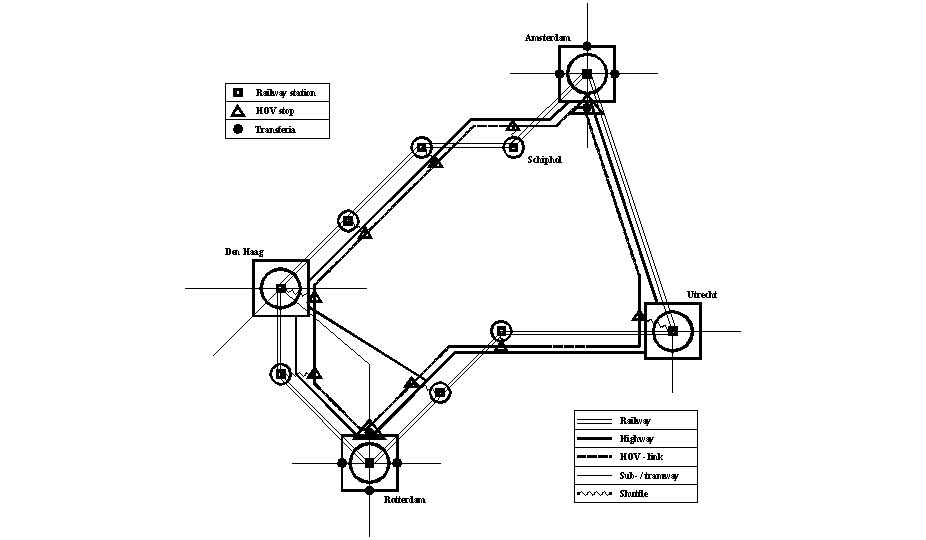
In a study for Deltametropolis - the western part of the Netherlands - the integration of landuse and transportation has been demonstrated. The existing transportation system will be completed by the high speed Transrapid system (Siemens) that interconnects new growth centres along the existing highways and adjacent to the old centres. The Transrapid stations are connected with inner cities, business districts and central railway stations by metro, light rail or shuttles. Hence, the proposed integrated transportation system can facilitate seamless multimobility by linking highways, railways and the transrapid system - definitely leading to a certain shrinking of space.
Introduction
In the Western part of the Netherlands more than 6 million people live and work. The spatial configuration consists of 4 cities of more than 400.000 inhabitants (Amsterdam, Rotterdam, The Hague and Utrecht) and a lot of cities, towns and villages around a rural country side, the so called "Green Heart". There are two mainports situated in the Deltametropolis: (1) Port of Rotterdam and (2) Amsterdam/Schiphol Airport. Especially the Port of Rotterdam generates freight transport over Northwest Europe. Amsterdam/Schiphol is an important hub in the international aviation network for passengers and airfreight.
The cities and towns are interconnected by highways and railroads. Around the cities of Amsterdam and Rotterdam a tangential highway system exists. Around The Hague and Utrecht this tangential system only partly exists. The public transport system can be considered as a hub-and-spoke system. The cities are interconnected with frequent rail transport. In the different cities a radial public transport system (metro, tram, busses) facilitates the downtown transport. These radial systems are also the feeders of the intercity rail network.
Up to the seventies each city and the belonging suburbs could be considered as a single socio-economic system. During the last three decades the housing- and labour market became integrated, however. Inhabitants of new residential areas do not depend on one city anymore, whereas private firms are more free to settle on any accessible location in the Deltametropolitan area. Recently the government wants to stimulate this integration into one metropolitan development (1). However, Deltametropolis differs strongly from other European metropolitan areas e.g. London, Paris, Berlin, Munich, Madrid or Milan. Deltametropolis is not one urban area, but a set of cities and towns, each with its own history and functions, interconnected by transport infrastructure. The average length and travel time of trips are relatively long. The average length of a trip by car is 15 km., by train 45 km. and by metro/tram/bus 15 km. Based on the actual landuse, the configuration of the infrastructure network and the available transport services the modal split is: car 55%, public transport 15% and bike/pedestrian 30%. So while stimulating one metropolitan development the issue of transportation is more important than anywhere else.
The existing transportation system of the Deltametropolis does not come up to the requirements, however. The most important problems can be summarised as follows.
The spatial configuration of the Deltametropolis potentially allows the development of a metropolitan transportation system that is competitive with transportation systems in other western metropolitan areas.
The transportation system of Deltametropolis
An analysis of the existing transportation system did lead to the following conclusions.
The main structure of the existing highway system is adequate. However, the capacity of the tangential highways around the cities is not sufficient. The design of these highways has to be changed by (1) realisation of separated pay-lanes for interregional transport, (2) improvement of the electronic transport management and (3) improvement of the capacity by reducing the speed to 80 km/h. The bone structure of the highway system of Deltametropolis should be extended to a inner circle of 2 x 4 lanes.
The main structure of the railway system is adequate. However, the capacity of the links interconnecting the central stations should be improved to 4 tracks to facilitate intercity- and regional trains. In the regions of Amsterdam, Rotterdam, The Hague and Utrecht regional trains can be used as feeders of the intercity system. In Amsterdam, Rotterdam and The Hague also metro/tram can be used as feeders. In doing so, it is necessary to improve the accessibility by car and parking capacity of the regional railway stations.
In the central area of Deltametropolis the existing railway system should be 'downgraded' to a high frequented lightrail system.
The implementation of the measures, mentioned above, results in a sufficient capacity to facilitate trips. However, the average travel time will only be shortened because of solving traffic congestions and a more frequent railway system. These improvements are not sufficient to obtain one metropolitan market. The target to reach this situation has been formulated as: "80 percent of all potential trips within Deltametropolis should be completed in less than 1 hour" (2). To realise one metropolitan market the average travel time of trips should be shortened, especially trips using public transport. To do so, it is necessary:
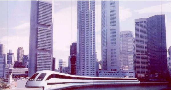
So, the existing system should be completed by a additional high speed system. The Transrapid system, developed by Siemens, seems the most favourable opportunity. The Transrapid system uses the principle of magnetic level (MagLev) elevation, has a maximum speed of 400 km/h, and a well performed accelleration.
Besides the target related to reducing travel time the introduction of an additional public transport system also gives the opportunity to real estate development on new areas with multimodal access.
The integrated Deltametropolis transport system
The backbone of the future Deltametropolis transport system is a circular network of railways, highways and Transrapid (MagLev), connecting the cities around a green countryside. The railway system links the central stations of cities and suburbs. The highway system is situated at the inner circle of cities and suburbs. Around the cities a tangential highway system is connected with the innercircle highway. The Transrapid is also situated at the innercircle. The alignment will be bundled with the highway system. The stations of the Transrapid will be situated at the outskirts of the cities. They will be connected by metro, light rail or shuttle with the inner cities, business districts and central railway stations. The Transrapid stations are accessible from the highway system as well as from the urban road system. So, the Transrapid stations can also be used as transferia (transferpoints) to facilitate seamless multimobility.
During the last decade the demand of real estate with multimodal accessibility is steadily growing. Within Deltametropolis the availabale capacity is limited though. Transrapid stations along the (tangential) highways in the outskirts of the cities, combined with real estate capacity, can provide in the demand. Real estate development of multimodal assessible locations has been proved succesful (Amsterdam Zuidas, Schiphol, Rotterdam Alexandrium). It seems that this development brings up new growth centres. The capacity of the pedestrian catchment area of a Transrapid station is ca. 150.000 m2 offices floor space, 500-1500 houses and 4000-10.000 m2 shops and leisure floor space. The needed parking capacity is 4000-6000.
Forecasting trips and modal split
The number of trips between the main cities in Deltametropolis is 145.000 (1998). The yearly growth will be between 0,7% and 3% in the time period 1998-2020. The national report on transportation assumes a yearly growth of 1,5% (3). The modal split between the railway system and highway is calculated to be 66% highway and 34% railway (1998, intercity-transport). Hence the number of intercity trips in 2010 will be 239 million. The new modal split for 2010 is calculated to be: car 140 million (63 per cent), railway 41 million (19 per cent) and Transrapid 39 million (18 per cent). The number of passengers of Transrapid can be extended by: (i) transfer passengers from outside Deltametropolis: 4.000.000; (ii) trips between the business areas at the Transrapid stations: 3.000.000; and (iii) trips caused by the changed distribution related to travel time (Brewer): 5.000.000.
So the total number of passengers using Transrapid in 2010 will be 51.000.000.
These figures are based on logit modelling, assuming that travel time is most relevant in the choice of alternatives. The origins/destination matrix used is derived from the Nations Travel Survey (OVG). To get insight in the sensitivity of the forecast a lot of reruns has been made with alternative locations of transfer points, travel time on links, and frequences of transport services. The sensitivity analysis shows that the modal split depends strongly on the location of transfer points and the available transport services from stations to destinations. The number of passengers using the Transrapid is ca. 80 million if Transrapid stations will be combined with central railway stations. The number of passengers using Transrapid will be ca. 15 million if Transrapid stations are located along highways without adequate transport services between station and destination.
Growth centres, transfer points and real estate development
Accessibility is an important criterion for allocation of housing, commercial activities and public services. The external accessibility by car is the best along the inner circle of Deltametropolis. If urban areas along the highway system gets access by public transport the most favourable locations for real estate development become available. The access by public transport can be realised in two ways: (1) the Transrapid system and (2) shuttles connecting the areas with inner cities, business districts and central railway stations.
Design and development of the growth centres are one of the future challenges of urban planners and architects. The problems to solve have to do with logistics, quality of design and financial feasibility. Especially the routing and handling of parking needs attention. Parking capacity up to 6000 cars had to dispatch ca. 2000 cars during peak hours. This means more than 30 cars every minute. The flow capacity of the entrances of the parking accommodation and the access routes to the highway and urban road system should be sufficient to avoid congestion and long transfer time.
New growth centres combined with multimodal transfer points require high building density. So, underground construction and multi use of space are needed.
The design and implementation of the Transrapid system as well as the development of new growth centres might also include weaknesses and threats.
The construction of the Transrapid system takes 6 to 8 years and an investment of more than 5 billion Euro. Based on cost-benefit analyses it is a feasible system if the number of passengers are more than 50 million a year. To provide this requirement national government, municipalities and public transport companies should tune their urban planning and transport services into an integrated transportation system including the Transrapid. However, there are a lot of practical and policy problems. The modal shift of passengers from train to Transrapid on intercity links is about 50%. The rail system as well as the Transrapid needs a feeder system of urban public transport. The cost-effectiveness of a two-pole-oriented public transport system will only be economically feasible in Amsterdam and Rotterdam.
Real estate development in new growth centres around the Transrapid station will have great impact. Urban transformation of the innercities needs to be stimulated. Business and services will leave the inner city. Housing and leisure (shopping and culture) may become more important. Especially historic inner cities have opportunities. However, regarding the potential capacity for real estate of new growth centres a temporary overflow of the market has to be feared.
Conclusions
F.M. Sanders is professor at the Delft University of Technology and head of the Department of Infrastructureplanning, Faculty of Civil Engineering and Geosciences
W. Ruiter is associate professor at the same Department.
Notes and Literature